Brian A. Morganti
2018 Chase Summaries
July 22 - August 3, 2018
July 22, 2018: Sun Day 1 - Departure/Travel Day: A late season start for my annual chase vacation, but with with a good prospect of severe storms in my favored areas of CO/WY/NE for the coming week. Eastern PA to Brownsburg, IN. 624 miles.
July 23, 2018: Mon Day 2 - Travel Day: I was still eyeing up the following day (Tuesday) for the potential of a pretty supercell somewhere in western/northwestern Nebraska. I positioned to Cozad, Nebraska which would put me in pretty good shape for the following day. 842 miles
July 24, 2018: Tue Day 3 - LP Supercell - Van Tassell, WY: After three days of eyeing up western/northwestern Nebraska the morning forecast still looked good for a few isolated supercells developing in this area by late afternoon. I monitored data/satellite and radar as I headed west and everything started to point to far northwestern Nebraska near the WY/SD/NE border region. I made my way to my favorite overlook area just west of Fort Robinson and watched a few distant cells on radar that had formed to my northwest. The southern most one started to look good and I had my first target storm to chase. My first photo below shows my view from the overlook looking WNW at the blow off anvil from this storm. There was no competition to its south or immediate north, so nothing to mess up the views as I got closer. I drove west on highway 20 to the Wyoming border where the highway immediately turned to a rutted torn up road due to road construction. It didn't matter as I did not have to go far. I drove west just far enough to where I had an unimpeded view of the storm to my northwest. I spent about 30 minutes enjoying the storm and taking photographs. There were no other chasers around and it was nice to have this one to myself...a big advantage of late season chasing.


As I drove south I let this storm pass by to my north, as shown in the first photograph below. It had lost its luster and was no longer severe warned. It was getting late so I continued south to Scotts Bluff and arrived there right at sunset. By now this storm had once again regained severe status and looked rather impressive on radar. It was now too far away to intercept before darkness fell, and was moving away to my northeast. I drove a little north of town and photographed the pretty updraft which was exhibiting a beautiful back sheared anvil in the setting sun. There were also weakening, but colorful updrafts to my west, one of which I photographed being reflected in an irrigation canal. Not bad for the first day of my trip! Scotts Bluff, NE. 408 miles


July 25, 2018: Wed Day 4 - Bust Day - Northeast, CO: There was a risk for severe storms in both north central Kansas and northeast Colorado. I favored the northeast Colorado region as it would keep me closer to where I wanted to be the next day. Severe storms did indeed form, but were not very photogenic and formed closer to the metro regions of the I-25 corridor. I played with one short-lived supercell that was enshrouded with lots of debris clouds from numerous storms that had formed nearby. I blew off the day early and headed to Brush Colorado for the evening. No photos were taken. Brush, CO. 367 miles
July 26, 2018: Thu Day 5 - Severe Storms - Colorado/Wyoming/Nebraska Border Area: A slight risk day for the tri-state border area. I drove north from Brush towards my target area and hung out just south of New Raymer watching the building cloud towers to my northwest. One of those days where it feels good just to be out on the open plains and knowing that storms would be forming later. I knew I would not have long to wait or far to go for the first severe storm of the day, so I spent a little time hanging around an old farmhouse while keeping an eye on data. Radar soon showed storm initiation to my north near Keota and I had a target storm to chase along my favorite gravel road (now blacktop) that goes from Highway 14 through Grover, CO. I had a good visual of this small rotating storm off to my east between Keota and Grover while it was severe warned, but it offered little structure as it drifted off to my southeast.


I left this storm go and headed farther north into Wyoming where the HRRR model was showing some isolated supercells in the Torrington to Lusk area later in the day. I wandered west of Lusk towards Guernsey as severe warned cells began to form in this area, but there was not much to see due to lots of competing showers and weak storms. I headed back east and stopped a little north of Torrington as one imbedded storm started to show a little base structure, but other than a little lightning this storm looked rather pathetic. Eventually this area of convection moved farther southeast and looked a lot better on radar when it reached Scott's Bluff, Nebraska...but was too late and too far for an intercept. Other big supercells stayed well to my north in northeast Wyoming, or back to my southeast near Cheyenne where I had been earlier. Just one of those days when my target area came up short and I had little to show for my efforts. I finished the day looking for pretty skies north of Torrington and found a pretty field of sunflowers beneath the anvil canopy of the storm I left go an hour earlier. Not the best day, but definitely better than the day before. Torrington, Wyoming - 268 miles driven.


July 27, 2018: Fri Day 6 - Severe Storms - Colorado/Wyoming/Nebraska Border Area: Another slight risk day for the tri-state border area. A few weak storms formed by mid-afternoon in southeast Wyoming, and one briefly turned into a mini-supercell with some decent structure as shown in the four time-line images below. All too soon numerous storms began to form and it was plain to see that competition between these cells would ruin the show.


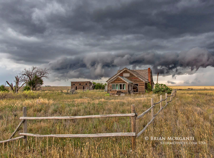
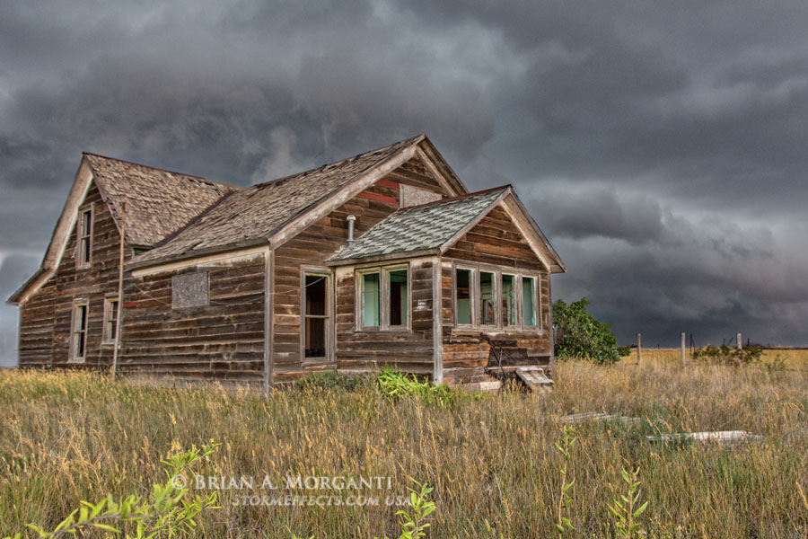
I then headed south after another strong cell on radar that soon became severe warned, but again structure was lacking as it got wrapped up with other storms to its north. Radar was showing a large and isolated cell a little south of Cheyenne. I drove south and could see a very long inflow band feeding this storm on its southeast flank. Curiously, the inflow band morphed into a series of Kelvin-Helmholtz clouds and I captured an image or two above the town of Burns, Wyoming as shown in the first image below. I dropped south of the Wyoming border into Colorado and then west into the Pawnee National Grasslands via a gravel road network in order to get closer to this storm. It had a rotating base and some nice structure at times, but as I got closer it was plain to see this storm was beginning to go downhill. I managed to get a couple of decent images of the storms weakening updraft base before turning around and heading back east. Along the way I stopped at an abandoned farmhouse to take advantage of the late day storm light illuminating the west side of this structure below a stormy sky.


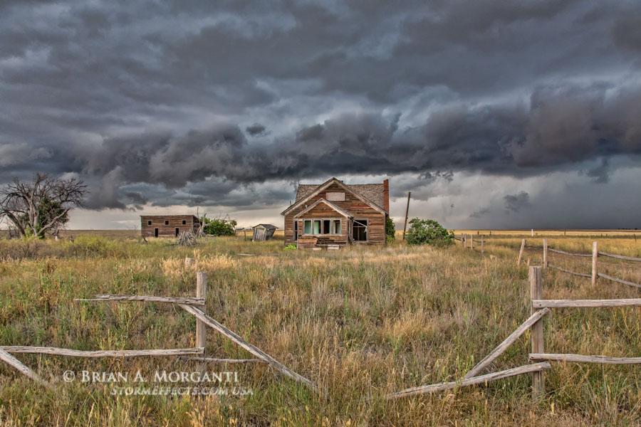
The storms were done and I decided to head to Kimball, Nebraska for the night. Along the way I spotted an old farmstead with multiple out buildings and could not resist stopping to explore and take pictures as I had about an hour until sunset. I spent about 40 minutes here, close to sunset and when I walked the distance back to my vehicle and took my last photo (as seen in the first image below) I was ready to head to the motel. But I could not find my keys...looked in all my pockets several times and came to the sinking feeling that they must have dropped out of my pocket somewhere back in that tall grass at one of the numerous places where I stooped down to photograph the structures from a low angle. I had an extra key hidden, but this set of keys had other important keys plus the only one that had remote access to the doors. The light would soon be fading so now I would have to retrace my steps and figure out best I could where I stooped down to take those low angle photos. I was about to give up, thinking I might have to come back here tomorrow when I very luckily spotted them lying in a small open area of the grass at one of the last places I stopped to take a photograph. With a big sigh of relief I headed back to the car and drove the last hour or so to my motel. There were big cells well to my south and these were diving south in the opposite direction from where I had to go, but it no longer mattered as this day was done. Kimball, NE 185 miles logged for the day.

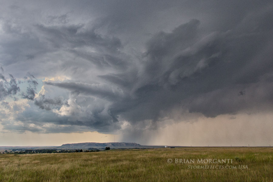
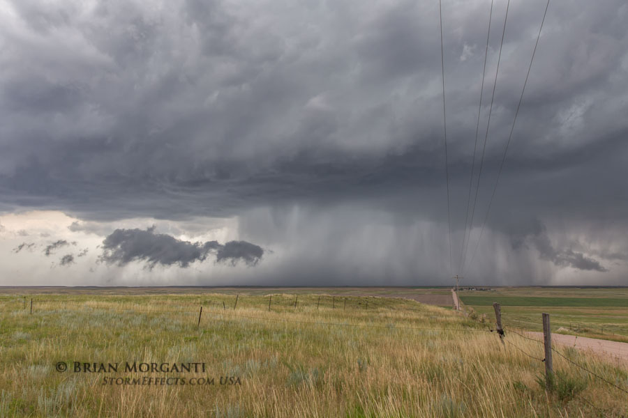
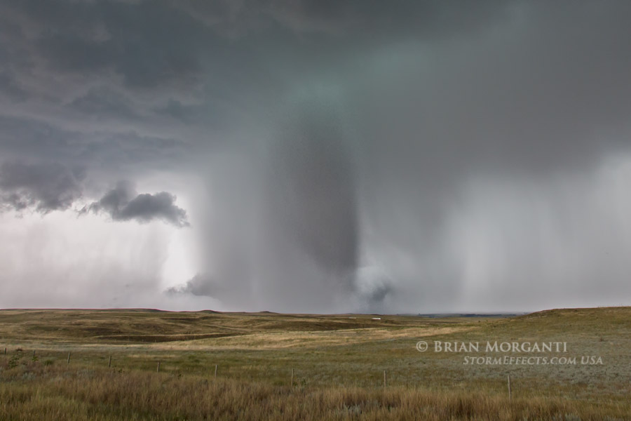
July 28, 2018: Sat Day 7 - Long-Lived Supercell & Tornado - Colorado/Wyoming/Nebraska Border Area: An area of enhanced risk for severe storms was set for the same area as the last couple of days, and I was already in excellent position right where I woke up. I spent a good part of the day hanging around in Kimball, Nebraska. After lunch I stocked up on some fresh fruit and food for later in the day and then spent the early afternoon looking at data under a shade tree in a park. It was only a matter of time until the storms would form and I was positive that I could just wait here and see a great storm by late afternoon. Of course I wasn't about to wait for any storm to come to me, and when the first radar returns starting showing up to my northwest it was time to get moving in that direction. An MD was issued for a good part of the tri-state border region and a watch would soon follow. I plotted a course towards a couple of cells forming to my northwest and as I passed the first couple I could tell they were not the ones to stick with. A stronger and more isolated cell was located about 25 miles to my northwest and was heading toward LaGrange, WY and that was the one that looked promising. I had some great views along the way when this storm became tornado warned, based on confirmed sightings. I had a very good visual from a distance but certainly saw no tornado dropping to the ground. I stopped at a high point east of town along with another chaser and we had a great view of the storm as it drifted south and east. The storm was still organizing and it was time to head south via Highway 215. One of my first photo stops yielded a very nice area of rotation that almost became a tornado as it descended from the mid-levels of the storm (see second photo below). I continued south on 215 and then east on a gravel road into Nebraska and then south towards Bushnell, NE. I stopped at a high point to look back as the storm and immediately spotted a weak landspout tornado to my north as seem in the third photo below. The next image is a wide angle view of the same scene a short time later.


This storm was really getting its act together and I had gained enough latitude, and now it was time to get east...and fast! I definitely did not want to use I-80 eastbound as I was on that section a day or so ago and it was down to one lane with slow moving trucks. Besides, heading east on parallel route 30 would be almost as fast, have me a little closer to the storm base, and give me the option to stop and take photographs if desired, not something easily done on the interstate. As I was approaching Highway 30 I noticed I would have to cross the RR tracks first, and dang it...there was a freight train approaching! I safely made it across the tracks, and good thing as this train was only traveling at about 20mph and had at least a hundred cars. I would have been going crazy waiting for this thing to pass as there was no time to waste. The storm was picking up speed and the base was rotating like a top as I headed east on 30 towards Kimball. A couple miles east of Kimball the rotating base became very ragged and low to the ground...it looked like a tornado may be imminent. I pulled over for a quick photo (first shot below) but could not linger long as a hail core was wrapping in from my immediate north. I jumped back in the car and raced to the east end of Kimball and stopped for the last shot I would get before going thru town. From this slightly distant vantage point I was able to capture a little more of the storm structure with ragged base as I looked back to my northwest. As I entered Kimball and headed south on Highway 71 a few hailstones began to fall. I wanted to get through town and then to a highpoint on the south side of I-80 for my next available look back at this approaching storm. A tornado had formed as I was heading through town and had since weakened some and become mostly shrouded in rain as I took the last two photos below. If you look closely at the last two images, you can detect I-80 in the foreground and a semi-trailer or two. Adds some to the overall perspective of what I was seeing.


As the tornado dissipated I continued south on 71 stopping on occasion to look back to my north. The storm was starting to move off to my east, and I would have to do the same. I found a gravel road that headed east towards North Sterling S.P., and then south a bit, and then east for a few miles, and finally back south towards Sterling, Colorado. I had great views of the base as I headed east on the first leg of the gravel road. I stopped at the intersection where the road jogged south the first time and took the first photo below. By now the storm was moving hard SSE and GRLevel showed hail markers to 2.75". The storm was coming towards me fast and I needed to decide "do I head back away from the approaching hail or make a run south and then east and hope that I can beat it". The decision was made after a quick look at radar as my back west option was quickly being overtaken by wrap around hail to the west of the updraft region. No good...so I had no choice but to get moving...and fast! I may have put myself in an awful position! The first south option was short and no problem, but the next east section was several miles in length. I watched the hail approaching from the north and really started to ramp up my speed as it appeared there was not chance I could outrun the hail. My only chance was to get to the next south option and blast straight south. Just as I slid around to the south option and gunned the throttle a saw the first hail stone hit the gravel in front of me and split in half. It was about baseball size...and then I saw another. I drove as fast as I could and then one hit the roof and sounded like it was hit with a sledge hammer. Up ahead I saw a large cottonwood tree overhanging the road with a space to park underneath. I slowed down a little contemplating this semi protection from the hail, but GRLevel was now showing 3" hail and I decided against it...and just kept blasting south. After about 3 or 4 miles I felt I was safe enough for a quick look back and then took the second photo below. The gravel road led right back to the main updraft area and the blue/green cloud contours in the foreground were absolutely beautiful! After a few more photo stops, I stopped one last time at the intersection of Highway 14. The storm was heading towards Sterling, CO and would be moving off a short distance to my east and then south. I took one last photo looking north from Highway 14 (third image) and then planned to go west away from the hail and then south and eventually back east towards the storm. As I plotted a course back to the storm from the west it began to weaken and there was no longer a big rush to get near the storm base. Instead I stayed well east hoping to get some late day colors from the storm. The last image was taken after sunset from a gravel road several miles east of Highway 63...north of Akron, Colorado. A very satisfying day with a long-lived supercell and tornado and a match for most any day found much earlier in the chase season. Fort Morgan, CO for the night with 275 miles driven.


July 29, 2018: Sun Day 8 - Tornado Warned Supercell & Severe Storms - Colorado/Wyoming/Nebraska Border Area: Yet another day with a slight/enhanced risk for severe weather in the same tri-state border region. I knew the route well, so once again I headed north from northeast Colorado first to Pine Bluffs, Wyoming and then north towards Albin via highway 215 just as a severe storm was in progress off to my northwest. I had a good, but somewhat distant visual of this storm as a sighted tornado was reported. The first two images below pick up a suspicious area extending to the ground with a visible dust swirl below, but certainly no clearly defined condensation funnel from my viewpoint. The storm was moving to the southeast rather quickly and it was necessary to drop to my south a couple of miles closer to the I-80. I got out to look at the storm but it didn't appear to be quite as well organized at this point. There were a bunch of cows in the foreground so of course I could not resist taking a photograph.


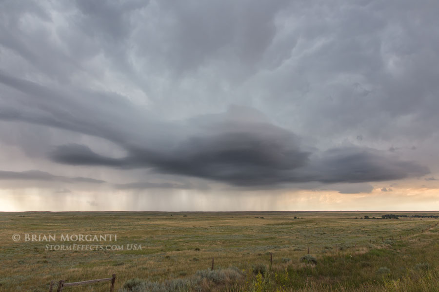
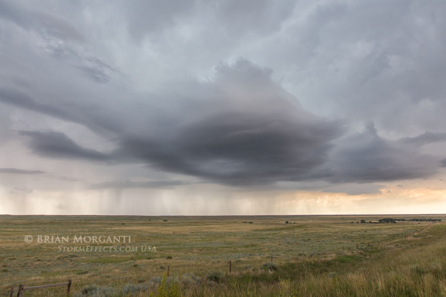
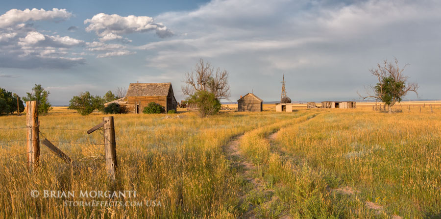
My next move was to drop south of the interstate and into Colorado to stay ahead of the storm. One of my first stops was near Hereford to look back and was amazed how much the storm had regained strength and was pushing out a very impressive gust front. The storm was more outflow dominate at this point but was now a lot more interesting to photograph. I continued south a few more miles to near Grover and stopped to take a panoramic image. I had put a little more distance between me and the storm and had some time to get a wide field vista of the approaching storm. The curved structure of the leading edge of the storm in the second image below is obvious and a distinctive bowl shape lowering is visible near the center of the storm. Again I dropped south a couple more miles and noticed an old abandoned farmstead located on a gravel road about a mile to my east. I knew this storm was fast approaching and figured this might be a good opportunity to capture some stormy skies with the farmstead in the foreground. The storm had once again weakened some and was more outflow dominant, but the desired effect was what I was after at this point.


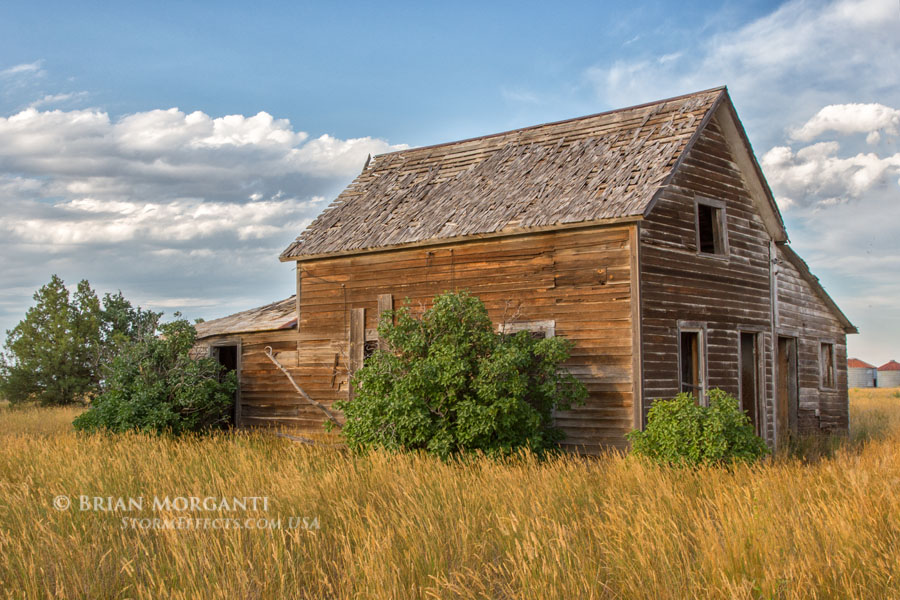
At Grover I decided to let this storm go as new ones were forming off to my northwest. I headed west from Grover and soon found another old house to photograph south of Hereford. I then continued south to Briggsdale to intercept a new tornado warned storm off to my west, but this one quickly cycled and weakened. More storms formed but nothing really got good or lasted long, and there was another problem. It was a Sunday and there were masses of local and family chasers out and about to play with the storms. I had only seen one or two other chasers the entire previous week, but today was awful...I even saw one SUV unload several small children and baby that was placed in a stroller. I had had enough at this point and worked my way back to Briggsdale and then north towards Kimball for the night. The skies had cleared completely to my west as I stopped to photograph the last departing storm moving off to my east above a field of pretty sunflowers. I finished the day once again in Kimball with 328 miles driven.


August 3, 2018: Fri Day 13 - Severe Warned Storms - Southwest NE / Northwest KS: I spent days 9 through 11 visiting with my son's family in Castle Rock, CO and then headed back out on Thursday Day 12. There were no storms forecast for this day, but I wanted to position myself closer to where severe storms were likely to form the following day. Spent the night in Ogallala, Nebraska - 333 miles. The prospects looked good for severe storms on Friday with a marginal risk in place from southwest NE to northwest KS. The day was hot, humid, and mostly overcast all day with smoky conditions from the wild fires farther west. I waited near Ogallala until late afternoon when the first severe storms formed about 40 miles to my south near Haigler, NE. Visibility was horrid along the way and I could only see dark bases to my distant southwest. These storms were barely moving, but new convection began to form everywhere limiting any one storm from becoming dominant. I continued south after new storms and encountered my first severe storm in Kansas near Bird City. Again visibility limited seeing much structure and I finally settled for a stormy photo-op along an old railroad bed leading west. I bounced back and forth in the Bird City area a couple of times between severe warned storms but became disappointed with each intercept. I continued south ahead of several storms to my west when one finally put on a semi-decent show just north of Colby, Kansas. I took several shots of the base structure before being hit by wind and rain and then headed into town. I rode out a couple of torrential rain storms and close lightning strikes while grabbing a bite to eat. As the storms passed off to my east I headed west a little in hopes of some last minute colors or structure, but it was well after sunset and there was just nothing to see. A rather disappointing day to otherwise very good week of chasing. Colby, Kansas - 208 miles for the day.


August 4 & 5, 2018: Sat / Sun Day 14 & 15 - Travel Home Days: Drove from Colby, KS to Marshall, IL on Saturday for a total distance of 793 miles. Had supper at an Arby's in Effingham, IL and realized I forgot my phone several miles east on I-80. Made it back just before they closed and luckily they had my phone waiting for me! Did the final leg home on Sunday and encountered a few severe storms near Wheeling, West Virginia and again in Western PA along I-70. No photographs were taken due to traffic, hills, etc. Total Trip mileage: 5545...most of which were logged getting to and from the plains.