2003 Chase Summaries
July 2 - July 13: Trip Two
Brian A. Morganti
JULY 2: Wed – Day 1 – Departure Day:
I wanted to get a head start on the long holiday weekend by leaving home around 4:00 PM EDT in order to be in position somewhere in NW IA or extreme SE SD by late Thursday. A sagging CF and OFB from the previous nights convection further to the NE along with a juicy air mass in place was certain to set off severe storms, but negatives included a strong CAP and the distance I needed to travel. I left home with 36,720 on the odometer and 547 miles later arrived in New Castle, IN.
JULY 3: Thu – Day 2 – Sioux City, IA – Tower Lightning!
After sleeping 5 hours, I got rolling around 8 AM CDT with the same target in mind. By mid morning I shifted my target area a little further east to SC MN which looked to have all the best parameters coming together for strong storm development...also, I would be able to make it there prior to sunset. A data stop at the Dubuque (DBQ) library during the early afternoon indicated subsidence had moved in aloft and MN/IA would be horribly capped until after dark. With nothing better to do, I decided to make the long drive across the state to Sioux City and hope to catch a piece of the action from the storms that were developing in west central NE. Along the way at a gas stop in Early, IA a nice lady noticed that I was a storm chaser and asked if I would like to see the tornado pictures she took from her front porch near Centerville, SD last week. Very nice highly contrasted views of a firmly planted tube and debris whirl just a few hundred yards away...she said it was “wild” and that I should have been there (I agreed!).
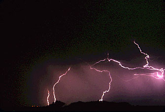
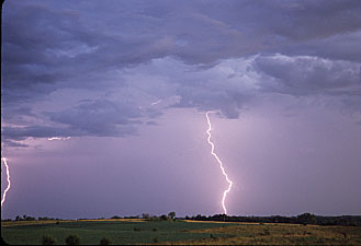
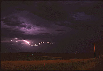
An MD, followed by a SEV was issued for the Sioux land by the time I arrived around 10:30 PM CDT. Radar indicated a somewhat intensifying bow echo just to the west, so I headed to a remote area along highway 75 just a few miles north of town. The distant city lights illuminated the approaching shelf cloud and dust plumes off to my west, as CG activity increased. I decided to meet the wind gusts head on via a gravel road that cut west. A wind gust of 51 MPH was recorded as soon as I stopped, but I believe SEV limits may have been reached just prior to this. The best lightning show occurred just after midnight as the storm complex moved off to the east. The highlight for me was being able to film several CG’s emanating from a 1500 foot tall radio tower about a mile off to my east. There must have been three dozen of these tall towers within my 180 degree view to the east, but for some reason the lightning really liked this one pair! I witnessed at least 8 or 9 direct hits, and was fortunate enough to capture about four of them. The tower would get “struck” at a hard angle, then another bolt would simultaneously stream off at an opposite angle, sometimes repeating and/or ending with a quick burst of anvil crawlers—it was wild! I’ve seen photos and video of this phenomenon, but this was a first time event for me! 789 miles logged.


JULY 4: Fri – Day 3 – SC NE Boom or Bust:
Bust it was!
I waited patiently all afternoon, along with a herd of cows, under a shade tree near Central City, NE in a 90/72 environment to no avail. I stayed as close to the boundary as possible by monitoring surface data and visual clues. An MD issued by mid afternoon for a good part of SC NE confirmed that I was in a good area. I drifted a little further south and west towards Kearney and made a final stand near Shelton. An area of enhanced CU began to bubble nearly overhead, but the bases were quite high and vertical development kept getting suppressed. Finally, one tower directly to my east made a run for the gold by exhibiting an impressive hard tower. Unfortunately the base was extremely high and the show ended in a flash of colors a short time later as the sun set. Shortly after sunset another growing tower beckoned directly to my south near Hastings. This one even put on an abbreviated light show---right up until the time I tripoded my cameras! Right after that (about 9:30 PM CDT) most of eastern NE was placed under a TOR watch box, but I'm not sure why. I'm not really sure what went wrong today...poor timing of SW support?,..weak convergence at lower levels? Perhaps the upper level support remained too far north at the critical moment. 364 miles logged.
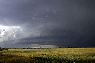
JULY 5: Sat – Day 4 – Elsmere, NE “Tail End Charlie” Severe - One of my all time favorite Chase Days!:
The Forecast: North-South Highway 183 in NE appears to be separating the best CAPE and Theta-e values to it's west, and the best helicity/low level wind shear to it's east. The last two days saw storm initiation well north of the quasi-stationary boundary located in the vicinity of I-80, so I suspect this may once again be the case today. Preliminary target is somewhere between BBW and Rock County. I anticipate the first storms to initiate over the Sand Hills to my west, and become better organized and severe as they move eastward along the Theta-e ridge into an area of increased directional shear.
The Chase: I hung around my initial target area along highway 183 in Sherman and Valley counties in central NE until mid afternoon waiting for a good reason to move. Like yesterday, I found myself located in an MD, followed by a SEV watch box. Weak convection stayed in place all day just a couple of counties to my north, but good insolation was occurring just to my west over the Sand Hills. By late afternoon I started to drift west along highway 91 toward an area of developing Cu. SAT imagery showed an area of enhanced Cu developing on an arc from O'Neil SW towards North Platte. Further to the SW, convection was breaking out in NW KS, and a beefy looking "tail end charlie" was moving on a southeasterly course from SD into NC Cherry County. This became my target storm.
A line of storms was developing just to my northwest near Almeria in Loup CO, but these appeared to be having a hard time getting organized. I decided to let these go in favor of the Cherry County storm that was approaching highway 83 south of VTN. This storm was TOR warned (Doppler indicated) and had dropped "damaging" hail in Crookston. I headed north on highway 7 at Brewster and could see the main updraft tower off to my NW, just as a TOR watch box was issued for my area. The only road that would "sort of" take me towards the southern flank of this storm cut WSW about mid-way between Brewster and Ainsworth. I cursed the Sand Hills as they teased me with only a glimpse of the base every mile or so. Finally, I had a semi-decent backlit view below the base as I approached Elsmere. I was looking NW and watched numerous suspicious lowerings, danglies, funnels, stovepipe scud, and who knows...maybe a stovepipe tornado! Even my Century Optics 2x tele-converter zoom lens could not discern any rotation. I had to get closer.

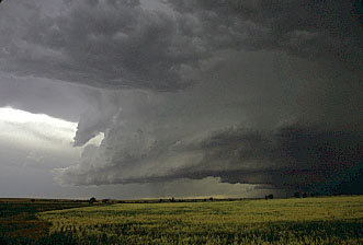
Soon, I found myself traveling down someone's old beat up one lane driveway, cursing myself for missing my turn...no wait, GPS showed I was now passing Elsmere! I saw one beat up old building and an even more beat up old pick-up...what happened to the rest of the town!? A gravel road then cut NW into an open area with an excellent view of the now much closer storm. Once again, I saw the same suspicious dark stovepipe lowering, but no rotation was evident and the sand hills blocked my view of this feature (scud bomb?) to the ground level. The low sun angle offered excellent back lighting below the updraft base however.


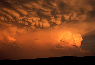
The rest of the line was rapidly approaching from the north however, so I had to film the pretty structure quickly and then get moving. As soon as I pulled away I got blasted by the outflow. I briefly got ahead of the main rain/hail core, only to be overtaken by another core. I pulled over briefly trying to decide what I wanted to do, and got rocked by an 83 MPH wind gust along with a few large hail bangs...not good! I saw some pine trees about a mile down the road and headed for the only "shelter" I could see. I was able to pull under a grove of old trees as hail began stripping leaves and leaving large splashes in a nearby pond. I hoped the 150 year old trees could survive at least one more storm. Once things calmed down a bit, I followed the back end of the storm east and enjoyed a spectacular mammatus show at and after sunset. I finished up the day near an old windmill enjoying the quiet and beauty of the now departing storm. 288 miles logged.


JULY 6: Sun – Day 5 – SD/MN Bust:
I stuck with my original target in extreme east central SD until late afternoon watching a razor thin line of Cu off to my north and northeast ahead of the approaching cold front. I kept hoping convection would take hold as this line moved further south into better instability and shear, but I couldn't keep my eyes off the tail end of established convection to my northeast in MN. I convinced myself things were just too capped (ignoring the MOD risk for my area) and could no longer stand idly by watching that "tail-end" convection pulse to my NE. Since this convection was moving ESE and angling away from my position, I didn't have much chance for an intercept, but I had to try since this storm had a good probability at becoming a tornadic supercell.
This storm pulsed several times in my two plus hour intercept attempt putting on a gorgeous show complete with feathered anvil and hard overshooting dome. I was finally able to get a few glimpses of the distant base to my NNE from highway 12 between Ortonville and Benson that revealed a beautiful and well defined wall cloud, even from a distance! It was now getting dark and the boundary to the SW of the cell started to fill in with low clouds blocking my view of the updraft tower. I had one last look under the base, but it looked like the inflow had now been undercut. 681 miles logged.
JULY 7: Mon – Day 6 – NE Sand Hills Storms at Dusk:
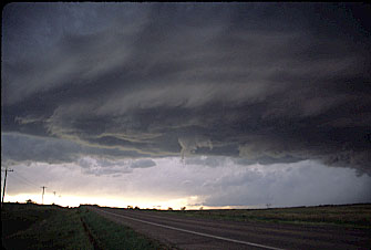
On Monday I initially targeted an area in SC NE north of the quasi-stationary boundary that once again stretched roughly E-W along the I-80 corridor. I didn't like the persistent remnant MCS debris that covered the northern two thirds of the state, so my target was shifting further to the SW where good insolation was occurring by early afternoon. I looked at data in Taylor and decided to head south to BBW and then SW to LBF. I had just left Taylor when I received a call from Matt Crowther, who was with Jim Leonard in the Broken Bow library...Great, I now had chase partners! We met up in Stapleton and hung around for a bit trying to decide whether we wanted to go SW or NW. We headed west on 92, then decided on Ogallala since convection had initiated in NE CO. By the time we arrived in OGA, the storms lined out to our WSW and were forming into a BOW echo. At the same time a somewhat isolated cell was forming to our NNW in southwestern Sheridan County. We decided to blast north on highway 61/92 for an anticipated intercept west on highway 2. By the time we got to Hyannis it was almost dark, but the storms were now just off to our west. We pulled over for a couple of photo ops between Ashby and Ellsworth, with the best show occurring just east of Ellsworth. To our south was the impressive bell shaped updraft of a rapidly developing storm. It was almost totally dark, but the frequent lightning illuminated the entire updraft and several distinct funnel shaped lowerings beneath the base. It tried hard to tornado, but never quite made it...perhaps there were just too many competing storms messing with the storms inflow. Either way, the structure and lightning made the trip north well worthwhile. 594 miles logged.
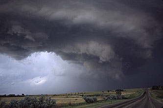
JULY 8: Tue – Day 7 – The Belle Fourche Beast:
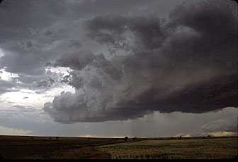
Tuesday, we had our sights set for somewhere in SW SD. The Philip/Kadoka area looked like a good place to start—strong SE flow, low 60 degree DP’s, CAPE and Theta-e ridge axis oriented NW/SE centered on this region, excellent UVV’s moving in by 00Z and...Kadoka always seems to be a hot spot! A data stop in Kadoka convinced Matt that we needed to head further NW. We figured by the time we got to Sturgis, a target storm should be at hand...and that’s pretty much what happened. We drove thru lots of elevated junky storms between Wall and Sturgis, but knew things would be better further west. At Sturgis, I pulled up a radar image and noticed a somewhat isolated storm beginning to form along the MT/WY border just west of SD. Also, there were a couple of more cells forming about 40 miles west of this storm. We had roads that would lead us right to this eastward moving storm, so we headed north while keeping an eye on anything else that might develop. Another storm formed further north, but we ignored this as soon as the RFB of “our” storm came into view. Besides, this storm had absolutely no competition to its south!
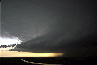
We set up our cameras just west of the Belle Fourche Reservoir, and filmed the pretty structure of this intensifying storm approaching from the WNW. At that point it didn’t look like it was about to tornado, but it did produce a couple of elevated funnel clouds and that were nicely backlit along a shelf like cloud that was arcing out to our SW. A couple of RFD slots cut into the main updraft, and the entire storm took on HP characteristic, but was still very photogenic. We packed up and headed east as a few hailstones danced around us, and the storm began to pick up speed. Road options were terrible, we could only head east a few miles to Newell, then 24 miles south before the next east option became available...ugh! We had a great view of some gorgeous base structure just to our north by the time we got to Newell. Radar indicated this was definitely the dominant storm and was “the storm of the day”! Just as we went south on highway 79, a TOR warning was issued for this storm and reported a tornado should be at Newell—NOW! We turned around for one last look at Newell from the top of a hill and were treated to some truly beautiful structure to our north. Although there was no tornado, the potential for one to form was now looking very promising. The long drive along highway 34 east gave us almost a constant view of this beauty to our north!. A beautiful white vaulted updraft tower with a dark base loomed above the green and gold fields to our north, and the CG’s increased dramatically the further east we went. We had one final colorful view of this storm from high atop a hill looking back to our west. The setting sun had turned the entire vaulted updraft to pretty shades of gray, rust, and purple, what a beauty! We started to get pelted with some marble size hail and headed east once again. Traveling south along 73 to Philip we were again treated to the massive flared updraft silhouette of the storm's leading edge off to our WSW. It was still nosing its way ESE, and radar indicated a hook-echo was forming that was heading right along highway 14 towards Philip. Lots of scary lowerings were illuminated by the lightning, but no funnels shapes were observed. 567 miles logged.
JULY 9: Wed – Day 8 – Iowa Storms:
Matt, Jim, and I left Murdo, SD on Wednesday morning thinking we had a good shot at finding a tornadic supercell somewhere in NE IA...possibly in the ALO area. As we traveled east towards Fort Dodge numerous storms began to erupt by mid afternoon. These soon formed into a linear mess oriented E-W parallel to highway 20. The most intense storm was near Fort Dodge and had a nice lowered RFB for awhile, but quickly became outflow dominant. At the same time a broken line of storms was oriented NE/SW just to the SW of DSM, and a more promising cluster of cells was forming in the OTM area. Waterloo surface obs told us to give up on that area and dive south on 35 towards DSM. The Ottumwa stuff was a bit out of reach and moving away from us, so we opted for the somewhat broken line of storms SW of DSM that would be heading in our direction. I got a nowcast from Bill Reid just as we approached I-80 that NW IA now had the best potential for tornadoes...ugh, we were just there two hours ago!
It was getting late, no storms had yet formed in NW IA, and we were only minutes away from what appeared to be strengthening storms just to our west. Just south of DSM we scooted thru the first messy cell. We then encountered a break in the line, but could see the next cell approaching from the WSW. This one had a very pretty and well defined shelf cloud punching well out in front of the rain core. The contrast was perfect for photography, but we were on the interstate and couldn’t stop. We exited a couple of miles further south, but by this time we were just about underneath the fast approaching shelf. We had time for one or two quick shots before we were nailed by outflow. As we headed back to the interstate we were buffeted by strong winds from the south, and a SEV was issued for this storm shortly thereafter due to a reported 80 MPH wind gust near Garden Grove, IA. I decided to end the chase just north of Bethany, MO. To my north the broken Cu offered a constantly changing kaleidoscope of colors. To my south brilliant blue CG’s and anvil crawlers streaked across dark blue storm bases. No tornadoes, but that final hour certainly kept the day from being a total bust. 650 miles logged.

JULY 10: Thu – Day 9 – East or West!?
Since I was in NW MO and there was a slight risk across the Ohio Valley today, it was very tempting to get an early start on my homeward trek. However, tomorrow there would be a boundary draped across C KS into NE CO that was sure to generate a slight risk of severe…now how could I resist that?! West I headed for the high plains, that’s were I wanted my last chase day to be. Lodged in Wakeeney, KS after 608 miles, a false start east (indecisive) cost me about 200 miles and 4 hours.


JULY 11: Fri – Day 10 – Last Day – Last Chance CO:
CFDG Forecast: Good moisture advection is now moving into NE CO from the ESE as depicted on the current SPC mesoscale analysis page. Good insolation has raised temps to near or above 90 across NW KS – EC CO, with a surface wind convergence line and CAPE bulls-eye located west of Yuma County. 1km SAT Loop shows the SW/T sliding in from the NW near the CO/WY border. The CAP is pretty strong (near 15 C at 700mb), but I am expecting (hoping) to see storms initiate to the north of highway 34 during the peak heating hours of late afternoon or early evening. These storms should then slide SE or even SSE along the Theta-e axis into NW/EC KS by late evening. Currently leaving the Burlington library (90/57) to set up shop near Yuma.
The Chase: I arrived in my target area by 2:00 PM MDT near Akron, CO and waited patiently for the storms to initiate to my NW. However, I was also keeping my eye on a line of persistent TCu that was percolating about 40 miles to my SSW near Last Chance. The winds were gusting to 24 mph out of the ENE, the Dp was adequate at 54, and an MD had just been issued for the NE CO...so I thought it should be just a matter of time. Plenty of time passed, and around 6:30 PM the towers to my south were beginning to look a lot more interesting, but radar indicated a lone thunderstorm had just initiated to my NW near CYS. I couldn’t see this storm due to a bunch of virga that was passing by to my north, but felt this may be the storm I had been waiting for since it should be moving into the better instability axis to its SE. But...I could see that cell to my south and it was looking better and better all the time, even though the DP’s were lower in that region. Time to get moving and make a decision!
I needed to make a commitment to either head north or south when I reached highway 71 at Brush. I decided the strengthening storm to my south might be the better play, since the cell to the north was weakening and looked pretty lame visually. Just as I was turning south on 71 (around 7PM MDT) a SEV watch box was issued for most of eastern CO. A short time later NWR issued a SEV (what the h---!) for the “LIC” storm for the Genoa/Bovina area based on a “marginally” severe hail report and 45 MPH wind gusts. Although the storm was pretty, it certainly didn’t look very threatening...especially with that high base! As I drove south through Last Chance filming the weakening storm to my SE (which barely loomed above the “Dairy King” sign at the juncture of 36 and 71), new towers began to form to my SW. It was now almost sunset as I watched these towers pulse, throw out a few CG’s, and put on a display of color from my vantage point on a hilltop overlooking the town of Limon. Unfortunately, these relatively weak and short lived storms were the only ones that initiated inside the SEV watch box. Capping seemed to be a problem earlier, possibly shallow moisture depth and lack of a lifting mechanism were the problem. Either way, it was nice to be on the only “SEV” storm in the state and to have one last film opportunity before my long drive back home to PA.
Also, it was nice to meet and chat with fellow CFDG’r Brad Carter on my hilltop “perch” north of Limon. 496 miles logged.


JULY 12: Sat – Day 11 – Travel towards Home Day:
882 miles driven from Colby, KS to New Castle, IN which means I would spend my last night on the road in the same hotel as my first night.
JULY 13: Sun – Day 12 – Arrive Home Day:
Another boring drive home. 551 miles on this day brings the total for the Trip Two to 7,017.
Weather Set-Up during Trip Two 2003
Most days either had a Moderate or Slight risk of Severe somewhere in NE, SD, or MN. A quasi-stationary boundary was draped across this region for days on end. NW flow aloft, easterly surface winds, and DP’s in the 60’s pretty much assured severe storms in proximity of the boundary each day. I found myself in an MD, followed by either a SEV or TOR watch box, on most days. The Sand Hills and southern SD saw the most action. Trip two was much more productive then Trip one. The last few years have been extremely productive from mid June into early July for the central/northern Plains.
Interesting Factoids:
Total Miles Logged for Trip Two: 7017 Total 03: 13,419
Including Tempest: 18,030
Average Miles per day Trip Two: 585
Total Days on Road Trip Two: 12 Total 03: 36
Total Days in Chase Mode Trip Two: 8 Total 03: 21
Severe Storm Intercept Days Trip Two: 6 Total 03: 13
Tornadoes Intercepted Trip Two: 0 Total 03: 2
Average Time to Bed: 2:00 AM
Gas Prices Paid Trip Two: Ranged from $1.33 at home to $1.61
With average of $1.58